Neighbourhoods are not designed. A few are, and they are conspicuous for it. The rest accumulate, and what they accumulate is a stack of decisions taken decades or centuries apart by people with no knowledge of each other, each constrained by what the previous layer left behind.
Layer one: the ground
Before anything is built, the land decides a great deal. Where water runs and collects, where the ground is stable enough to build on cheaply, where a slope is too steep for a cart, where a river can be crossed. Old settlements sit where crossing was easy and flooding was not. Areas that stayed as fields until late were often the ones that were wet, steep or awkward — which is why the housing on them is newer, more uniform and laid out by a single hand.
Layer two: who owned it
The pattern of land ownership at the moment of development is the strongest predictor of what a district looks like. A large holding released in one piece produces long straight streets, consistent house types and a single architectural period, because one owner made one set of decisions. A patchwork of small holdings produces irregular streets that follow old field boundaries, abrupt changes of house type at invisible lines, and odd triangular sites where two grids failed to meet.
This is why you can often see a former field boundary in a street plan centuries after the hedge was grubbed out: the boundary was a legal fact before it was a physical one, and legal facts outlive hedges.
Layer three: the plot
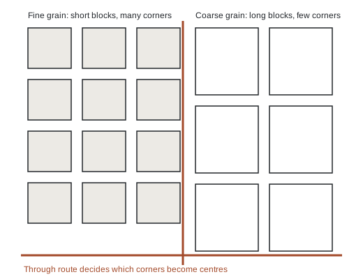
Plot width determines house type. Narrow plots produce terraces; wider ones produce semi-detached and detached houses. Depth determines whether there is a garden and whether a rear extension will ever be possible. Block length determines how many corners a neighbourhood has, and corners are where corner shops, pubs and small businesses went, because a corner has two frontages and more passing feet.
Fine grain — short blocks, narrow plots, many corners — produces the walkable, mixed, busy district that people describe as having character. Coarse grain produces quiet, uniform, car-dependent areas. Neither is better; they suit different lives. But grain is nearly impossible to change once built, which is why it is the most durable characteristic of any place.
Layer four: when it was built
Building periods are legible from the street, and they carry practical consequences as well as aesthetic ones. Ceiling heights, wall construction, window sizes, the presence or absence of a damp-proof course, whether services were designed in or retrofitted, whether the roof structure allows a loft conversion: all follow from the decade. Anyone who has owned two houses of different periods knows they are different machines requiring different maintenance.
Layer five: everything since
Then come the alterations. A house built for one household becomes flats and sometimes becomes one house again. Front gardens become parking. Shops become houses, and occasionally the reverse. A road is widened; a railway arrives, closes and becomes a path. A large employer opens and shuts. Each change leaves traces, and the traces are the reason two streets built in the same year by the same developer can feel entirely different fifty years later.
How change actually happens
Neighbourhood change is usually gradual and occasionally abrupt. The gradual version is turnover: households leave for the ordinary reasons, and who replaces them shifts slowly with relative price. Areas change hands one house at a time, and the process is slow enough that residents often notice it only in retrospect.
The abrupt version follows a change in access or a change in what the land is allowed to be. A new station, a road closed to through traffic, a large site released for development, or a change in what may be built alters the calculation for every plot at once. Access and permission are the two levers that move a district quickly; almost everything else moves it slowly.
This is a general account of how districts take shape. It describes no particular place and makes no claims about any specific neighbourhood, street or property.